
By Edith Cherry and James See – January 26, 2021

Visitors Center: Corner of Ripley and Broadway, Mountainair, NM 87036
Access: 505 847-2585 https://www.nps.gov/sapu/index.htm
The Salinas Pueblo Mission area was continuously occupied from about 900 AD to the 1670s. These locations highly emphasized trade: they were between the diverse ecosystems of the Rio Grande Valley and the plains; they were near extensive salt beds, a valued trade item that gave them their Spanish name; and, Abó Pass is the only way to travel through the mountains for miles north and south.
There were other pueblos in the area, but Abó, Quarai, and Gran Quivira house the most complete remains of the Pueblo and Spanish Colonial periods. Abó and Quarai residents were members of the Manzano cluster of the Ancestral Pueblos (formerly called Anasazi) who settled most of central and northwestern New Mexico, while Gran Quivira residents were members of the Jumanos (Hu-MAN-os) Cluster of the Mogollon (Mug-ee-YOWN) cultural group that stretched all the way from southwestern New Mexico.
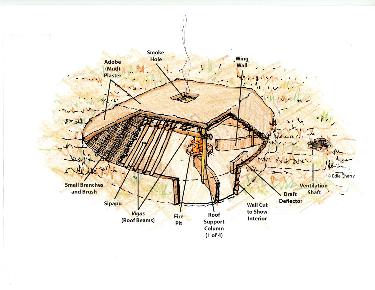
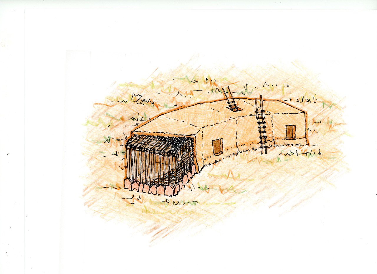
The earliest architecture in this area has been studied near Gran Quivira. These dwellings were pit houses, first occupied about 600 AD and later from 900 AD to 1150 or 1200 AD. During the 1200s, above ground structures, called jacales (Ha-CALL-es) appear. By 1300 AD, the walls of jacales had been reinforced with local masonry and were becoming masonry structures, initially one room thick. These masonry prototypes formed the room blocks of pueblos (Spanish for “town” and “people”) found in all the Salinas sites and all over the Southwest. Another structure type found in these villages is the kiva, a ceremonial space. These building types were the first architecture in many areas of New Mexico.
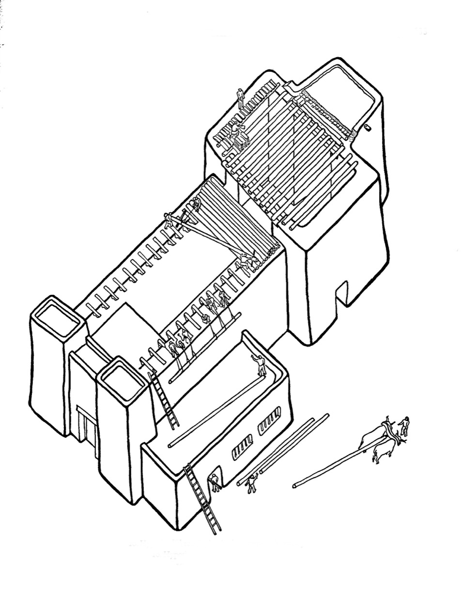
Room blocks were composed of, usually, one-room units stacked together. In the case of the Salinas sites, the walls were made of stacked masonry held together with mud mortar. The width of the rooms was determined by the length of the roofing logs, vigas, available from local forests; the length by what was a culturally appropriate room size. The rooms might be stacked up to three or even four stories high. Entries could be by ladders and openings in the roof, or by doorways, depending upon the needs of the site.
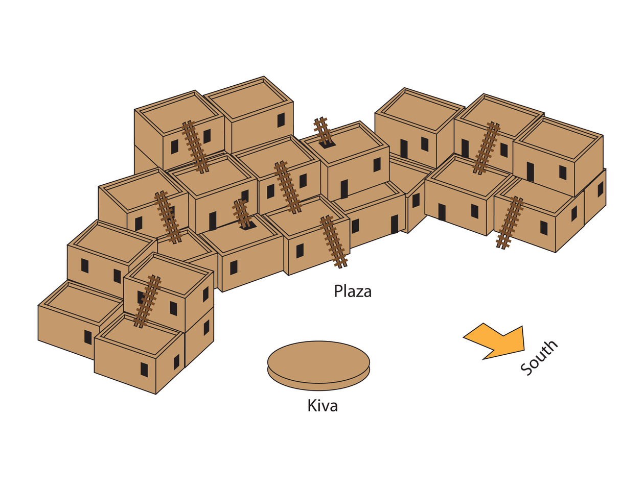
Often, room blocks were arranged to take advantage of southern exposure so that outdoor activities would have the benefit of the winter sun and the buildings themselves would shield the users from the north winds. Sometimes, a kiva was located in or near the plaza, depending upon the ceremonial needs of the residents.
Early Spanish contact occurred in 1598, but the 1620s marked the arrival of Franciscan priests who came to stay, intending to convert the natives to Christianity. Their knowledge of religious architecture, formed by their experience in Mexico and Spain, assumed churches were usually cruciform in plan and usually roofed with combinations of stone arches or barrel vaults. These curved stone roofs required a skill set and tools unavailable in New Mexico; so, all the roofs of these Mission churches were made of timber beams called vigas, with thin branches, latillas, spanning the vigas, covered with brush and mud plaster as the final roof covering.
Each of the three Salinas sites uses these basic architectural prototypes and combines them in slightly different ways, responding to cultural preferences, available materials, site circumstances, and solar orientation, as all architecture attempts to do. Alas, the architecture could not protect these industrious inhabitants from drought, disease, and the Apaches raids. By the mid-1670s the survivors were forced to flee to other pueblos in the Rio Grande Valley and beyond.
Salinas Pueblo Missions National Monument
National Register of Historic Properties: #66000494 (1966)
Learn More:
https://www.americansouthwest.net/new_mexico/salinas-pueblo-missions/national-monument.html
https://en.wikipedia.org/wiki/Salinas_Pueblo_Missions_National_Monument
2003, Kaiser, Harvey H., An Architectural Guidebook to the National Parks, Southwest: Arizona, New Mexico, Texas, Gibbs Smith Publisher, Salt Lake City, UT, pp. 166-178.
1940, Kubler, George, The Religious Architecture of New Mexico in the Colonial Period and Since the American Occupation, The Taylor Museum, Colorado Springs.
Special Thanks:
To Marc LeFrancois, Chief of Facility and Resource Management, Salinas Pueblo Missions National Monument, for his kind and careful review of this post.
_________________________
Abó
El Misión de San Gregorio de Abó
Location: 9 miles west of Mountainair on US 60, one-half mile north on NM 513.
Access: 505 847-2400 | https://www.nps.gov/sapu/learn/historyculture/abo.htm
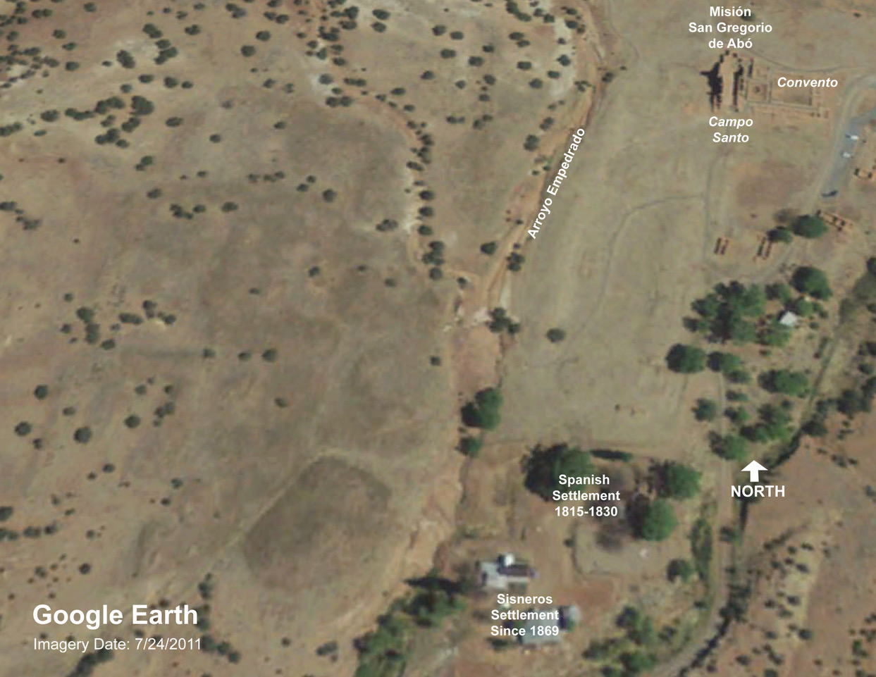
The Abó site is located on Abó Pass at the southern end of the Manzano Mountains on the trade route to the salt beds and the plains beyond. Arroyo Empedrado, that runs through the site, was and is a relatively reliable source of water. Red sandstone underlies the entire area providing a source for masonry, and the Manzano Mountains produced roof timbers and firewood.
The pre-Spanish residences, kivas and plazas on the west side of the arroyo, are believed to have been occupied originally in the 1100s; then abandoned for a period. Tiwa language speakers of the Manzano cultural group reoccupied them by the 1500s. The population was estimated at 1,600 in 1641. Houses were composed of rectangular rooms, up to three stories high in some areas, and kivas were disbursed amid the housing groups. Many of the plazas had southern exposures, providing comfortable domestic and ceremonial outdoor use in winter.
Spanish Franciscan friars began conversion efforts at Abó in 1622. The first San Gregorio de Abó Church and convento (Spanish for priests residences and offices) was completed about 1627. The nave was in the same place as the south end of the later church, but was shorter and simpler architecturally. One surprising feature of this church complex is the kiva located in the center of the claustro (Spanish for cloister).
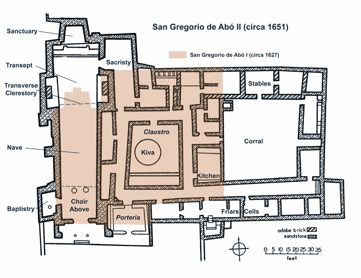
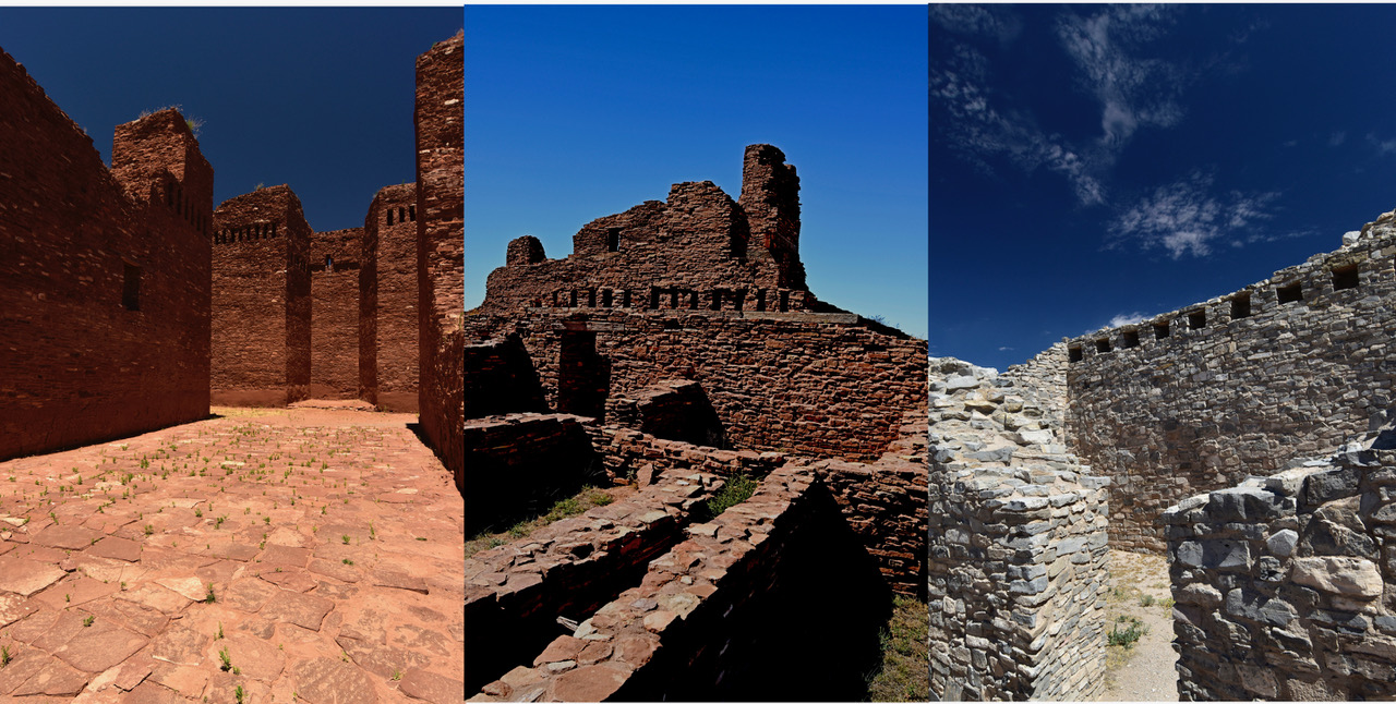
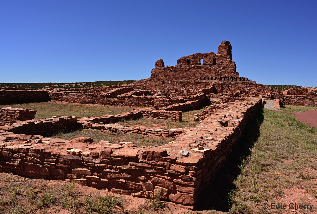
The second San Gregorio de Abó Church lengthened the main structure to the north. The walls rose to about 50 feet high and were topped with crenellations. Substantial buttresses were added to the walls. The roof beams are believed to have been 2 feet square and over 25 feet long, supported by corbels at the edges. A transverse clerestory spanned the south end of the transept allowing sunlight to fall on the altar. A choir loft was located at the entry end of the nave. One can imagine what an impact the acoustic properties of the church had on the Tompiro people once they had completed the construction.
The pueblo and mission at Abó were abandoned around 1672, due to a severe drought, disease, and Apache raids from the plains. The site was quiet for many years until Spanish sheepherders arrived in 1815. Apaches also pushed them out, but other Spaniards, specifically the family of Juan Jose Sisneros, settled there permanently in 1869. The remains of their early constructions can be seen to the south, southeast of the church. The ruins of a plazuela, a small courtyard, are still standing. Further south are the homes and farm buildings of their descendants, who farm the area today.
Pueblo: 1100s AD
Abandoned: 1673 AD
Architect: Ancestral Puebloans
Contractor: Ancestral Puebloans
Church of San Gregorio de Abó I
Completed: 1627 AD
Architect: Fray Francisco Fonte
Contractor: Ancestral Puebloans
Church of San Gregorio de Abó II
Completed: 1658 AD
Architect: Fray Francisco de Acevedo
Contractor: Ancestral Puebloans
National Register of Historic Places – National Historic Landmark: #6000497 (1966)
Learn More
National Park Service website: https://www.nps.gov/subjects/travelspanishmissions/mission-san-gregorio-de-abo.htm
Archaeology at the Salinas Missions: http://npshistory.com/publications/sapu/hsr/chap10.htm
Historic American Building Survey Drawings: https://www.loc.gov/resource/hhh.nm0151.sheet?st=gallery
Excellent aerial photo of site by Adrie Heisey. See: Capone, Patricia, “Mission Period Ceramic Production and Exchange” in Archaeology Southwest, Spring, 2011, pp. 15.
_________________________
Quarai
El Misión de Nuestra Señora de la Purisima Conceptión de Cuarac
Location: From Mountainair: 8 miles north on Highway 55 and 1 mile west at the village of Punta de Agua.
Access: 505 847-2290 | https://www.nps.gov/sapu/index.htm
Quarai is just east of the Manzano Mountains at the location of a reliable spring. As at Abó, red sandstone underlies the entire area, providing a source for masonry, and the nearby mountains provided firewood and roof beams. Temporarily occupied as early as 1250 AD, and abandoned by 1400 AD, Quarai was reoccupied around 1500 AD by Tiwa speakers of the same Manzanos Cultural Group as the Abó site.
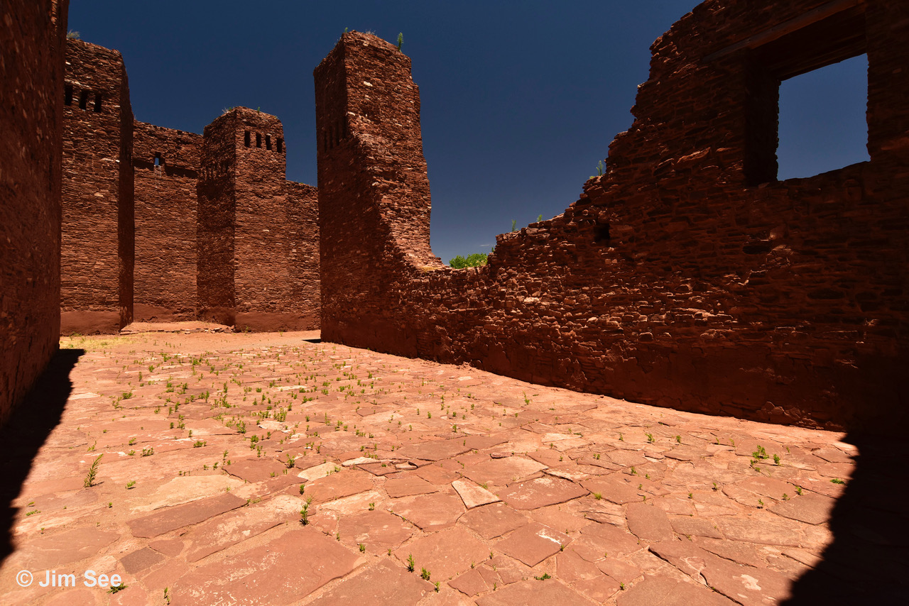
The Quarai Pueblo had around 1,000 rooms in six or seven groups arranged to form plazas, most with southern exposures. In some places, the structures were three stories high. Room construction was of local red sandstone and rectangular in shape. By the mid-1600s, the population is believed to have grown to 600 to 700 people, including Native and Spanish residents.
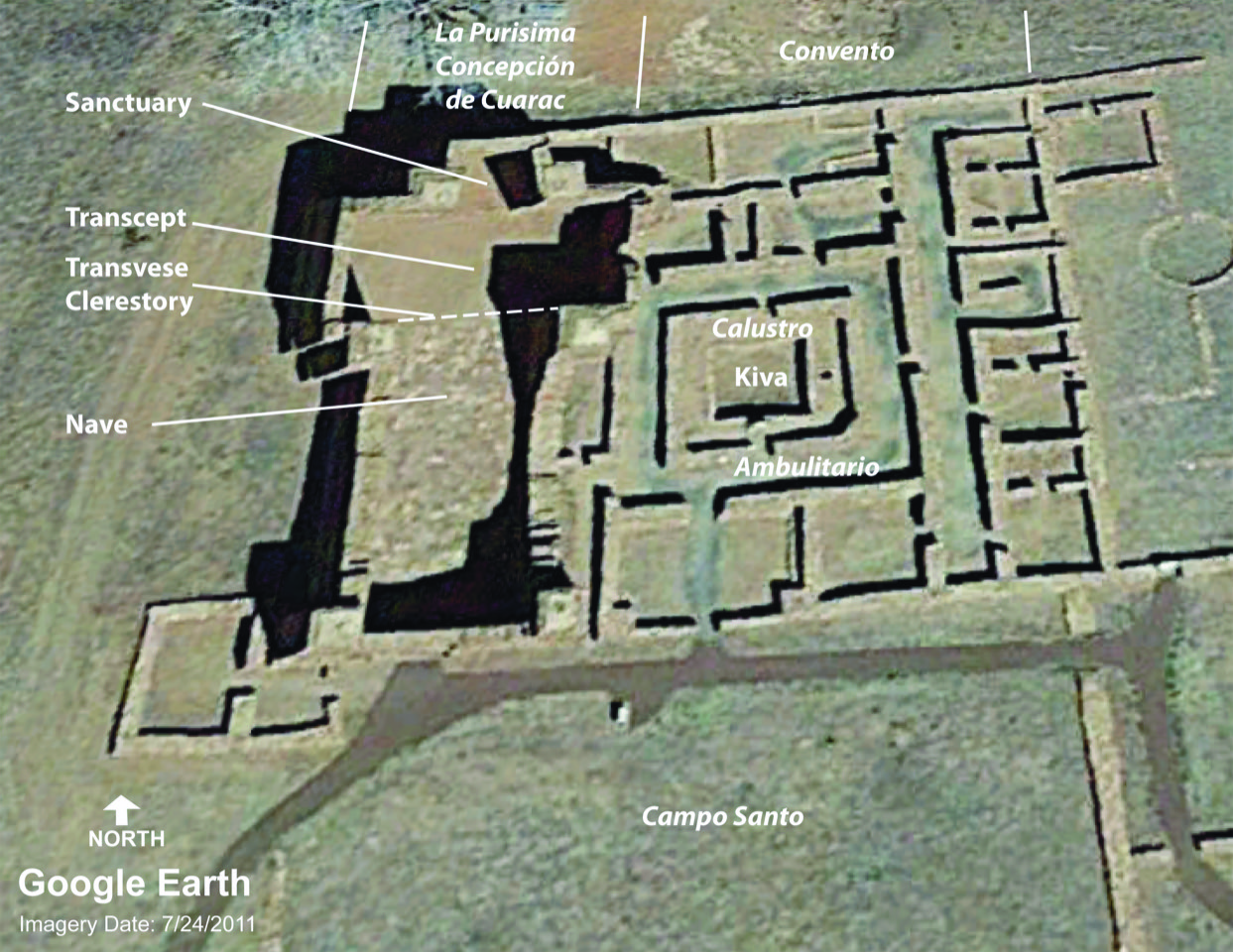
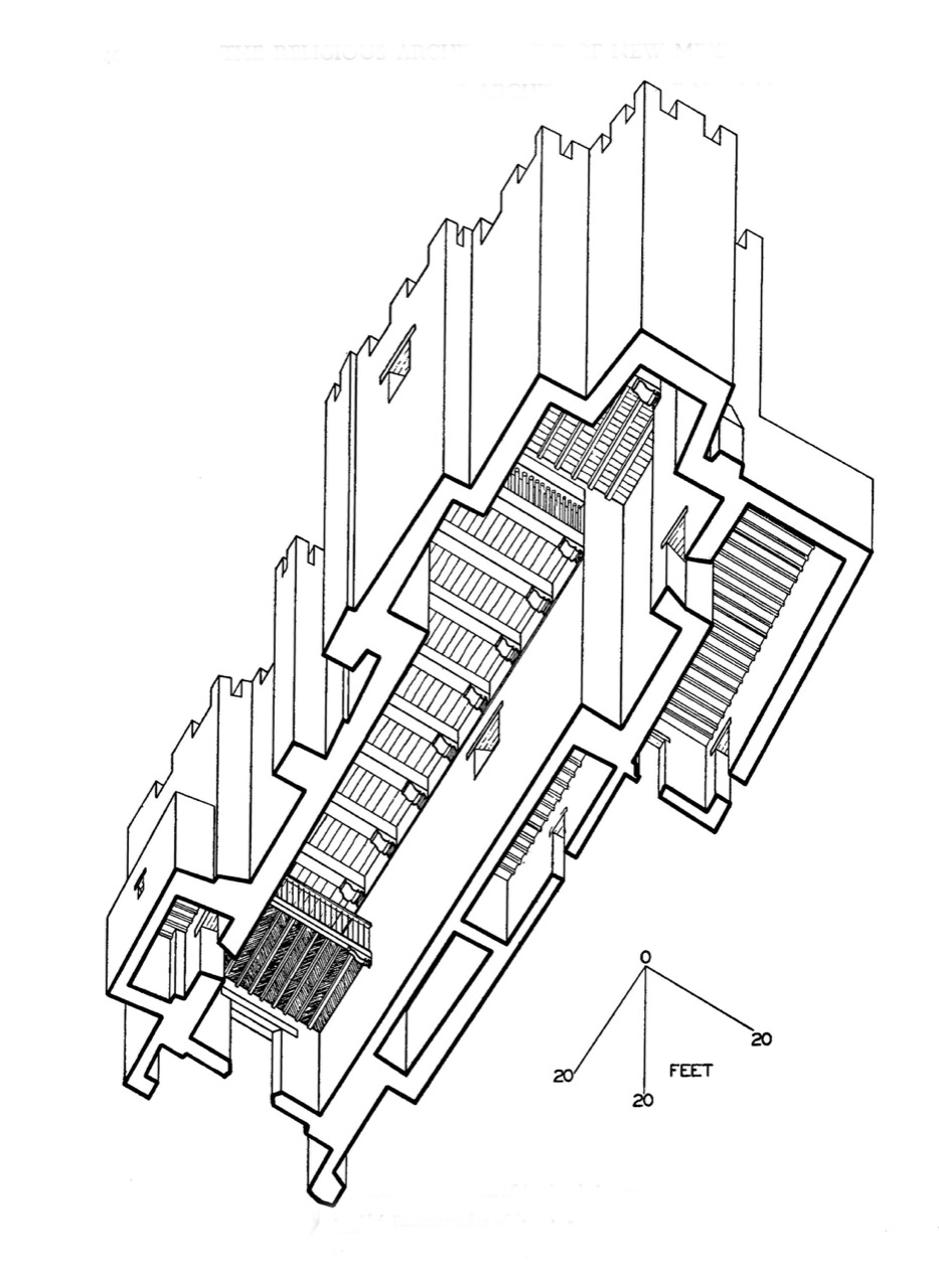
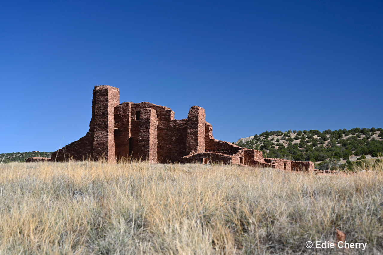
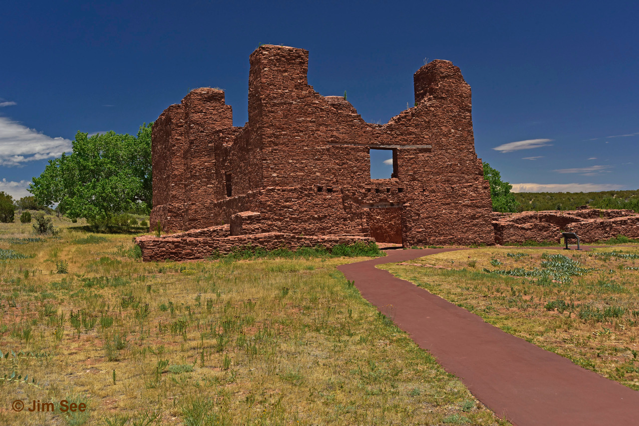
El Missión de La Purisima Concepción de Cuarac has the basic plan of a Latin cross. The dimensions of the church are about 108 feet long and 28 feet wide. The floors are red sandstone slabs. The walls of red sandstone average about 4-1/2 feet thick. It is believed that the transept ceiling was higher than the ceiling of the nave and the sanctuary, and the south-facing surface of this transverse clerestory was open, allowing south light to shine on the altar in the sanctuary. Also, the west and east walls of the transept had very high windows that would add light to the north end of the space. Walls were plastered in white with decorations painted under the direction of Friar Gutiérrez.
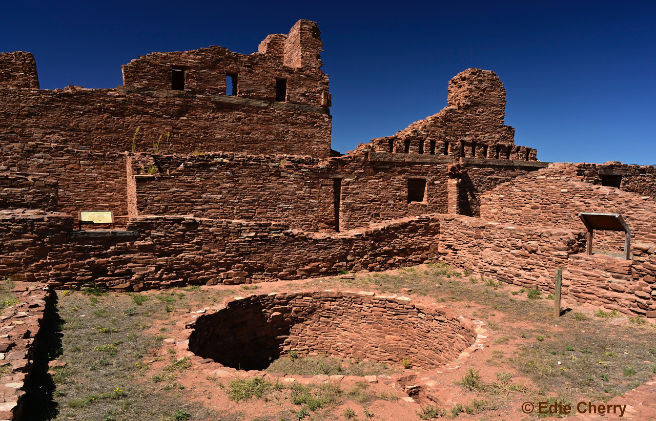
The convento housed the residences of the priests. As at Abó, there is a kiva in the center of the claustro, however in this case, the kiva is square. Some of the convento rooms were used in the mid-1600s for the Holy Office of the Spanish Inquisition for New Mexico headed by Fray Estévan de Peréa.
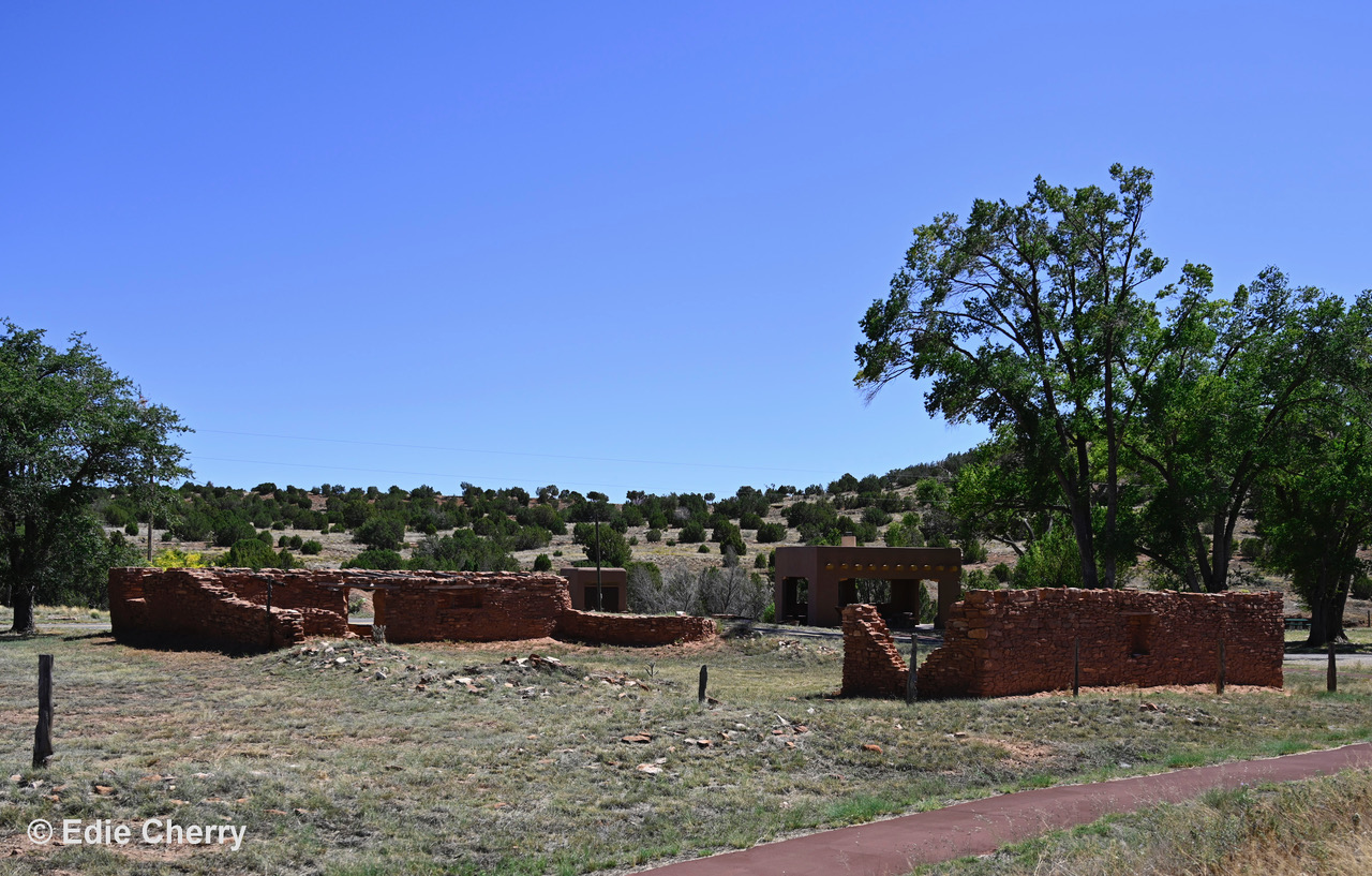
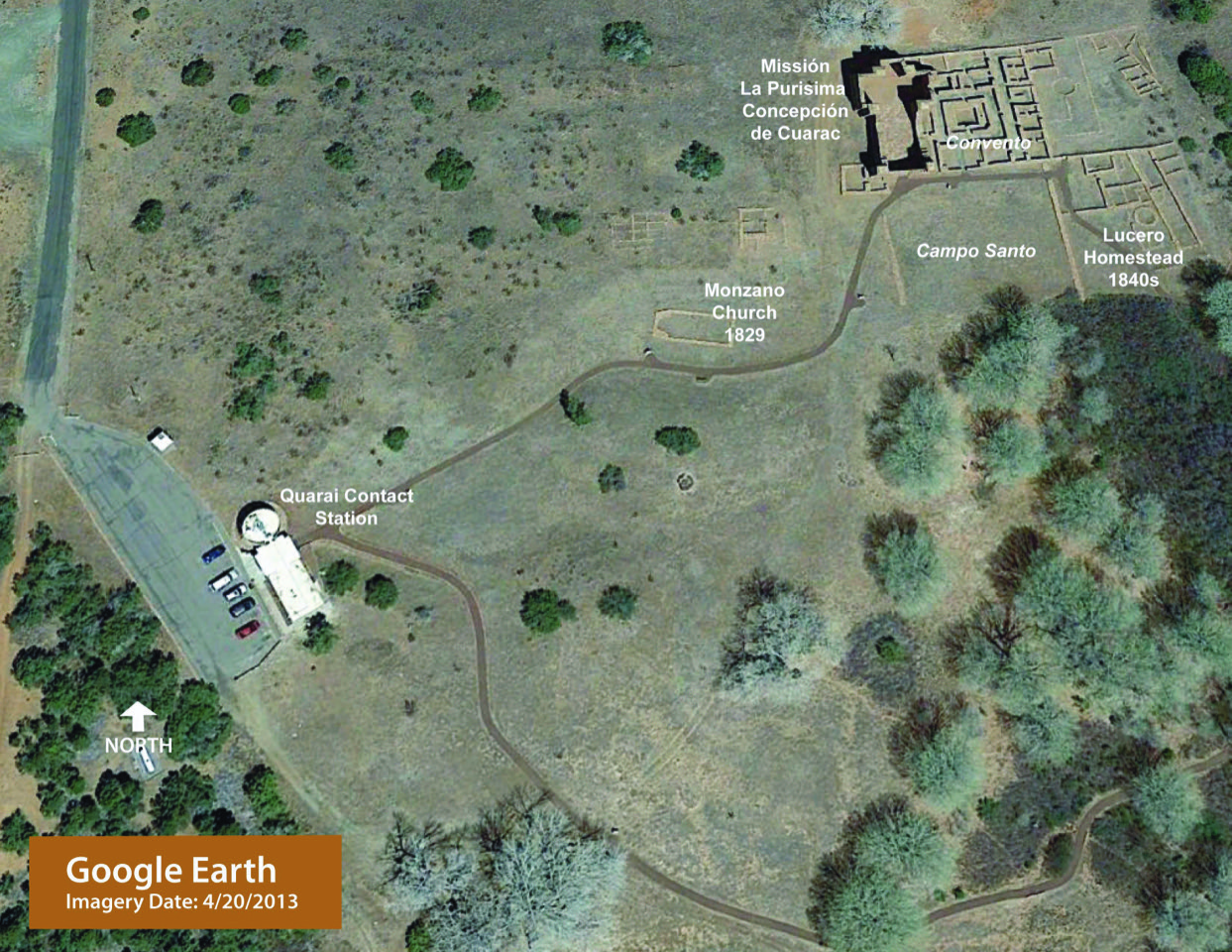
As with the other Salinas missions, by 1675, Quarai was abandoned and remained so until the families of Miguel and Juan Lucero moved into the convento rooms in the 1820s. They, too, were subject to Apache raids and left. In late 1829, the residents of the village of Manzano began to build the church to the southwest of the mission church, but never finished it. The Lucero family returned in the late 1840s and built new structures southeast of the convento, including a torreón.
In 1935, as part of the New Deal efforts, excavation, stabilization, and some restoration of the church was conducted.
Pueblo: 1250s AD
Abandoned: 1675 AD
Architect: Ancestral Puebloans
Contractor: Ancestral Puebloans
El Misión de Nuestra Señora de la Purisima Conceptión de Cuarac
Completed: 1632 AD
Architect: Fray Juan Gutiérrez de la Chica
Contractor: Ancestral Puebloans
National Register of Historic Places – National Historic Landmark: #66000498 (1966)
Learn More:
National Park Service website: https://www.nps.gov/sapu/learn/historyculture/quarai.htm
Description of archaeological studies at Quarai (Scroll down past discussion of Abó):
http://npshistory.com/publications/sapu/hsr/chap10.htm
_________________________
Gran Quivira
El Misión of San Buenaventura de Las Humanas
(Other Names: Las Humanas, also spelled Las Jumanas. Also called Tabirá until 1939.)
Location: 25 Miles south of Mountainair on State Highway 55
Access: 505 847-2770 | https://www.nps.gov/sapu/learn/historyculture/gran-quivira.htm
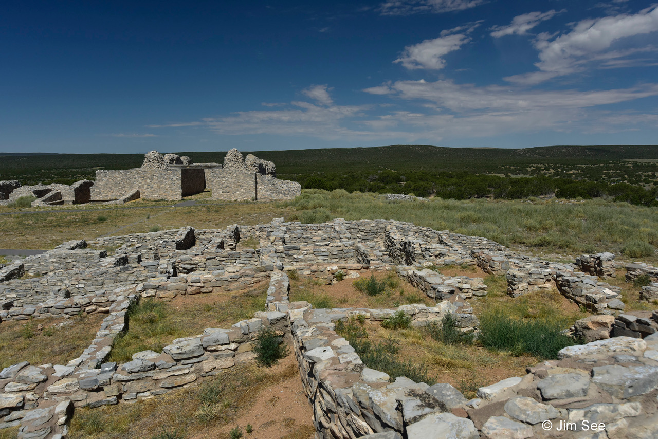
Gran Quivira is located southeast of Abó Pass, still within the ancient trade routes between the Rio Grande Valley and the plains. The terrain and geology are different from Abó and Quarai. Gran Quivira is closer to the Gallinas Mountains, with an underlying strata of limestone. Because it was located on a hilltop, reliable, running water was not nearby, making life more difficult there. Residents coped by using wells and cisterns, and constructing catchment basins for rain runoff. The ridge of the hill runs east-west and drops off on the west edge. There is a commanding view to the north and south. Culturally, the inhabitants of Gran Quivira were part of the Jumanos cluster, a Mogollon group who spoke Tompiro.
Initial, but intermittent, settlement in the Gran Quivira area began before 600 AD with pit house and later, jacales structures on the eastern slopes of Chupadera Mesa. By 1300 AD full masonry and adobe mortared pueblos could be found clustered around enclosed plazas.
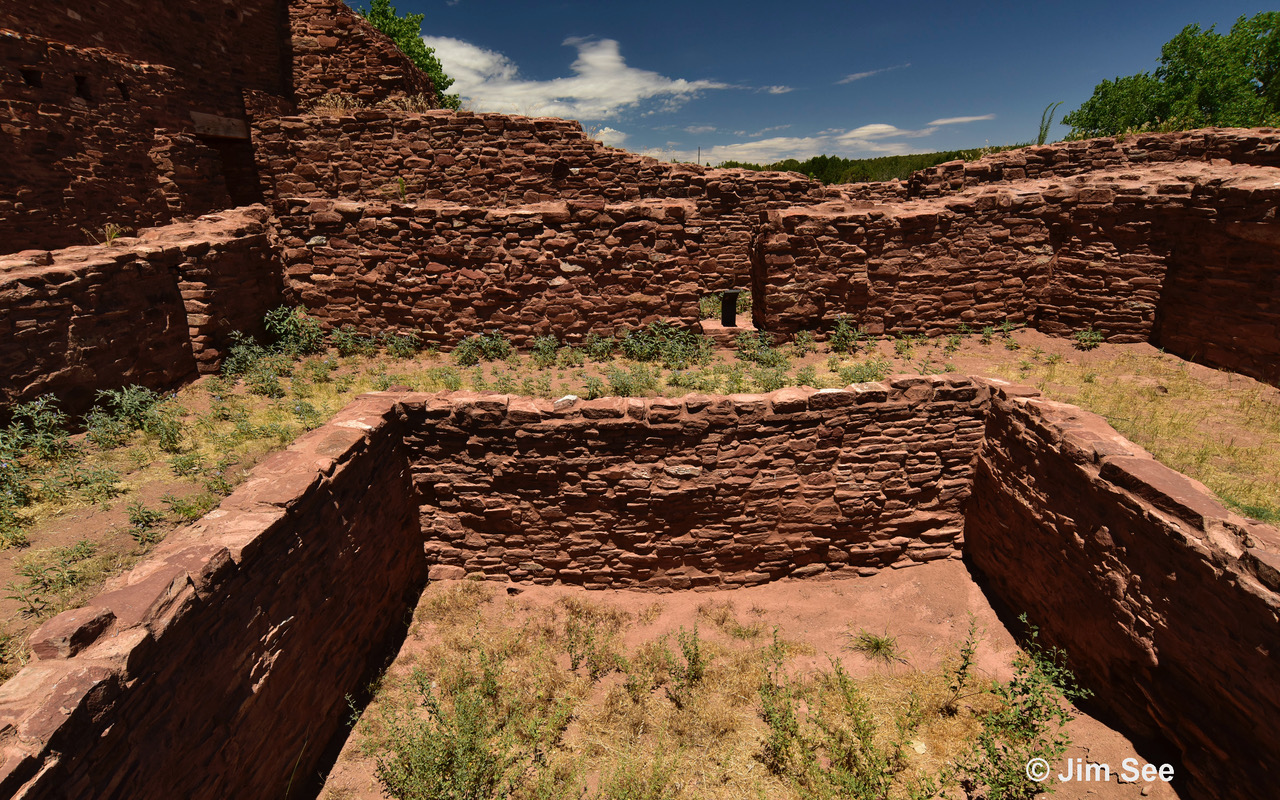
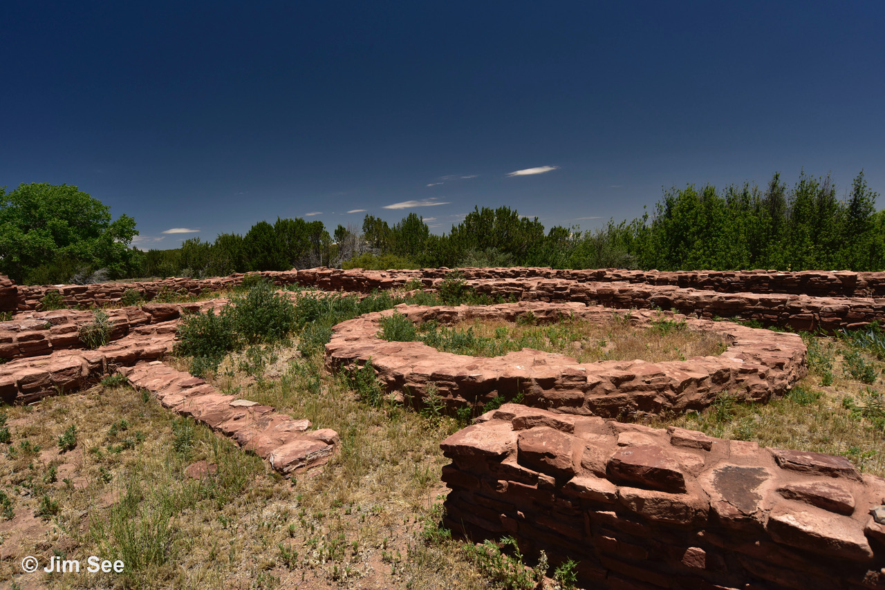
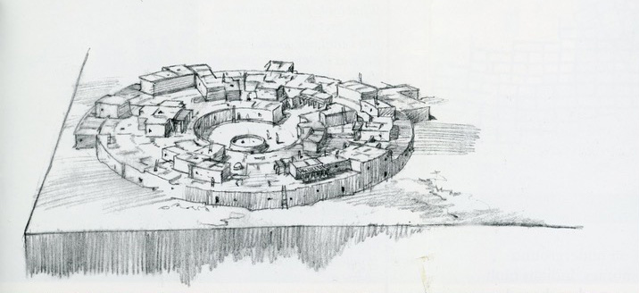
From 1300 to 1400, the pueblo, located under Mound 7, was a circular form with wedge-shaped rooms and a single, central plaza and kiva. The masonry of this pueblo, was secured by a yellow caliche mortar and very carefully done. It consisted of more than 200 rooms in five to six concentric circles. Such an architectural configuration focuses on the center, but deemphasizes the relationship of outer rings to the center as the population grows and more rings are added.
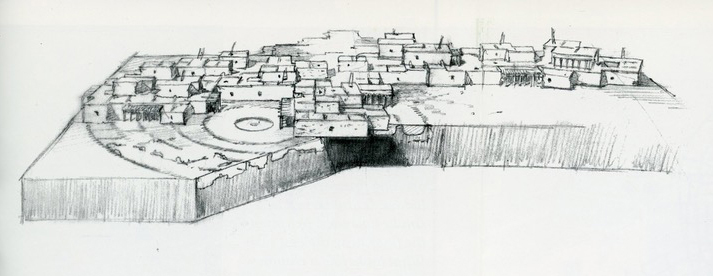
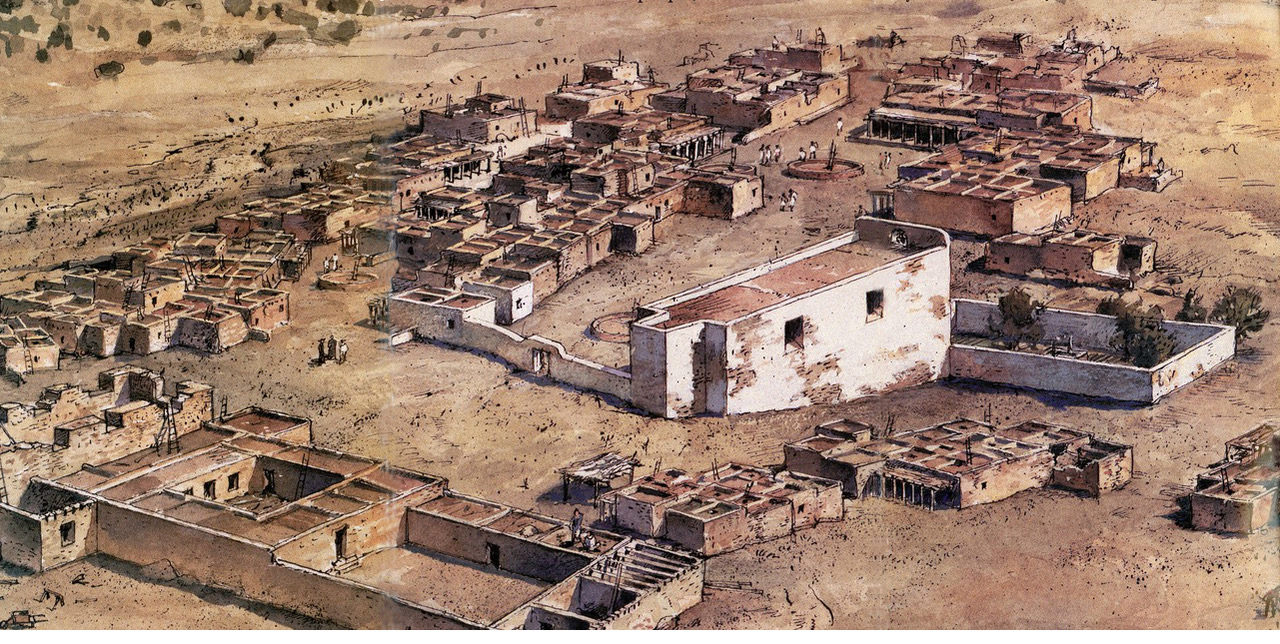
Beginning around 1550 AD, the rectangular grid architecture, found today, began and was built over the wedge-shaped rooms that had been filled with debris, perhaps for some time. Limestone blocks were secured with an ashy-colored mortar, with somewhat less care than the original masonry tradition. This configuration allowed much greater flexibility of social grouping and relationship to plazas and kiva locations. Gran Quivira grew to 200 rooms by 1600, and was the location of large trade fairs. When the Spaniards arrived they initially tolerated the use of the kivas, but in the 1660s they forbade their use. The Jumanos responded by converting rectangular inner rooms in Mound 7 into hidden kivas.
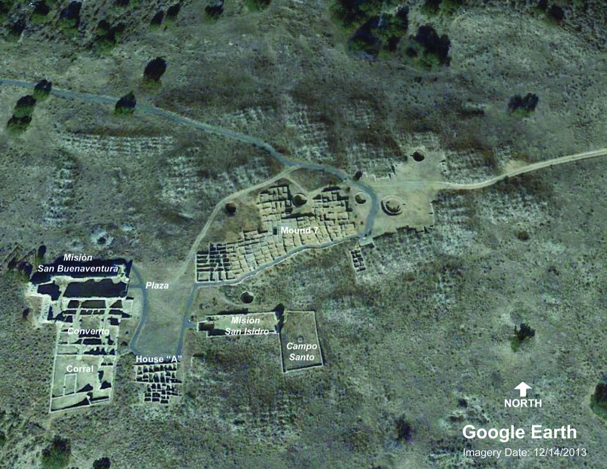
The Spanish Franciscan priest, Fray Letrado, was responsible for the design of the first church at Gran Quivira, the Mission Church of San Isidro, built by the resident Jumanos beginning in about 1629. This church was a simple rectangle with a small Sanctuary at the west end. The roof of the church was 15 to 20 feet above the floor, and a small choir loft was raised above the east entrance. The interior walls were plastered with red and black decorations. A low-walled campo santo is located south of the entrance. Existing nearby room blocks were used as the convento. Note on the Site Plan that a kiva is located just north of the church.
The later Mission of San Buenaventura de Las Humanas was begun in 1660. The site sloped significantly down to the west and required construction of a platform with retaining walls 8 feet high in some places. Both churches are oriented with the door to the east whereas the other two mission sites have the church door to the south. This change is probably due to the slope of the land. It is easier to build a flat floor across the slope, than in the line of the slope.
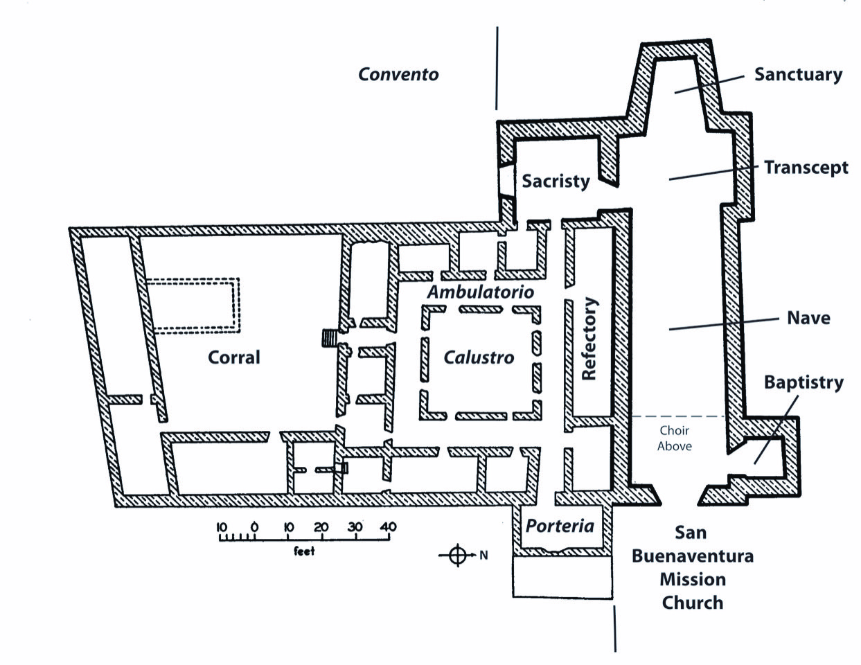
This church is a cruciform plan with sufficient length to the transepts to receive altars in addition to the main altar in the sanctuary. The nave housed a choir loft with highly decorated beams above the east-facing entry. The room to the north as one enters was the baptistery, and the room to the south of the transept is the sacristy. The small room at the front is the porteria, a waiting area for those wishing to see the priest.
The convento is similar in plan to the other two Salinas missions, but without a kiva included. The claustro has a complete ambulatorio around it. To the north is the refectory. The other spaces are the friar’s cells and offices. To the south is the corral where the livestock were kept.
There is much debate about whether this church was finished before the friars and residents abandoned Gran Quivira in 1672. Apparently, mass was held there before they left, but the construction may not have been completed.
Circular Pueblo: 1300 AD
Abandoned: c. 1400 AD
Architect: Los Jumanos
Contractor: Los Jumanos
Rectangular Pueblo: 1550 AD
Abandoned: 1672 AD
Architect: Los Jumanos
Contractor: Los Jumanos
Missión Church of San Isidro
Completed: 1635 AD
Architect: Fray Letrado and Fray Francisco de Acevedo of Abó
Contractor: Los Jumanos
Missión of San Buenaventura de Las Humanas
Almost Completed when Pueblo was abandoned: c.1672 AD
Architect: Fray Diego de Santander
Contractor: Los Jumanos
National Register of Historic Places: #15000355 (2015)
Learn More
National Park Service website: https://www.nps.gov/sapu/learn/historyculture/gran-quivira.htm
For a discussion of the confusion about names of Gran Quivira and names of the churches see: http://www.npshistory.com/publications/sapu/hsr/app3.htm
For a discussion on “The Extent of Construction of San Buenaventura” see http://www.npshistory.com/publications/sapu/hsr/app4.htm
Historic American Building Survey Drawings; HABS for Gran Quivira: seehttps://www.loc.gov/resource/hhh.nm0152.sheet?st=gallery
01/26/2021

Leave a comment